When I moved to the Babbitt/ Ely area in the 1970s, I immediately found a fantastic playground. The Tomahawk Trail ran from just outside of Babbitt to Highway 1. Crossing that road, it continued deep into the Superior National Forest, almost to the edge of the BWCA. Old logging and forest roads branched from it almost like the veins on a leaf.
Now, the Tomahawk is a story unto itself – one that we will address at length in a future article. This week I’m looking at what I found at the very end of this marvelous route into the backcountry.
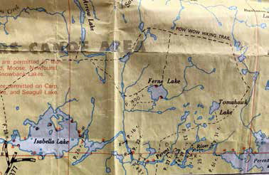
Old roads and trails extended from a hub at the old townsite of Forest Center like spokes on a wheel. A portage down to Isabella Lake left the old parking lot - later found to be extended into the Boundary Waters and made smaller to where it is today. As the name implies, the east road proceeded south and east of Isabella Lake and the Perent River past Boga Lake before turning and heading north. Several other short roads headed south and west to near the old town site.
The north road took almost a straight path to the south end of Lake Insula with multiple smaller logging roads branching out along the way. One larger branch was routed easterly, passing near Powwow Lake. This part of the system became known as the Powwow Trail.
I’ve seen old black and white photos – and even some video – of what it was like in the late ‘40’s and into the early ‘60’s.
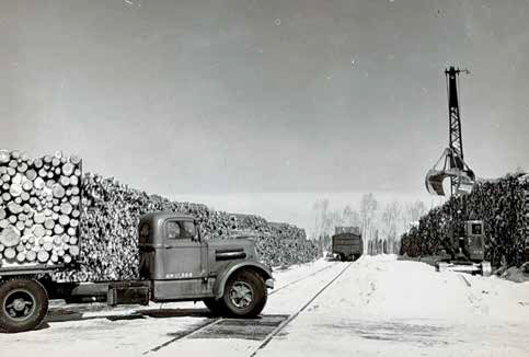
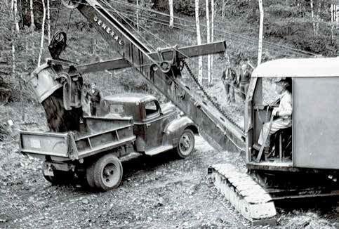
Wide gravel roads, well made and maintained. Huge culverts prevented troubled spots at all times of the year. Large semitrucks hauled logs. Bulldozers built new roads and cleaned them of snow in the winter. Cranes lifted the timber onto flat beds and tanker trucks hauled gasoline and oil supplies to service all the machinery. A railroad crossed at the southern end of the North Road. Logging camps with several buildings were near the ends of some of these roads – Camp 6, Polly Lake and so on.
I spent dozens of outings exploring the North Road. In the late ‘70’s and early ‘80’s the main route was still like a major highway. A spur of the Tomahawk brought you right to the edge of the Boundary Waters.
We used to park where the boulders announce entry into the park. It was an effortless hike.
You could have easily still driven the logging trucks and caterpillars
and skidders at least as far as where the current trail splits to go north or west. Indeed, I’ve had people tell me that they were able to ride a bicycle (and even a motorcycle) to the south end Insula into the early ‘80’s. My daughter Kaija was born near the end of September of 1982. By the middle of October, I was pushing her in a stroller almost three miles down the North Road. It was as easy as pushing a stroller on a sidewalk.
It was a favorite of mine during grouse season. Early morning would find the birds picking grit along the gravel road, with miles of side roads thick with grasses and clover affording cover and plenty to eat. One road that veered off to the west passed near enough to Pelt Lake that it was worth the effort to portage a canoe and sacks of decoys into that small body of water to hunt for ringnecks and mallards as they migrated down from the Pas, Manitoba. Tom Wetzel, Larry Simonich and I watched a cow moose on the far side of the lake evade some hunters one fall as it laid down in cover as they approached. The blaze orange clad hunters walked mere feet from the animal as they passed by. Five minutes after they passed the huge gal, she stood and ambled back towards where she had come.
Every trip offered a surprise.
A chance encounter with a moose. Wolf tracks and scat littered the road surface. Deer still inhabited the area and snowshoe hares were abundant. Quite often moose sheds could be found.
My friends and I would explore this area, especially in the fall. Many times, we would practice map and compass skills by choosing an entry point and destination during lunchtime at work. Then on the weekend we crashed through the brush to see if a small pond might hold some ducks, or a new trail could be found. Jim Haugen, Doug Dreschler, Tom Wetzel and Larry Mischke were most often my traveling companions.
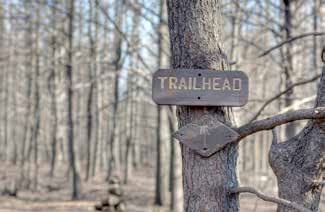
As time passed, the sides of the roads and trail invaded the open space. Even the gravel covered North Road became narrow with alder brush creeping towards centerline and clover and timothy grass filling in any open spots. Even so, the Forest Service used existing forest roads to develop a trail system of over fifty miles. Two loops started and ended at the Forest Center parking lot – one to the east and the other to the west.
They were primitive and not used much past the first two or three miles of each loop. Indeed, hikers attempting the full route would quite often get lost. One such adventure was included in the book “Lost in the Wild” by Cary J. Griffith.
As time went on, the roads became less distinct, and the activities of beaver flooded the trail in many places. The furthest reaches of the trail system were seldom visited. Still, I would cruise portions of these trails several times each summer and fall. Then came September of 2011.
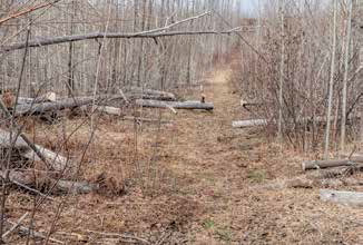
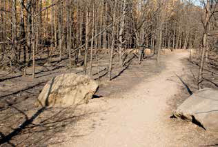
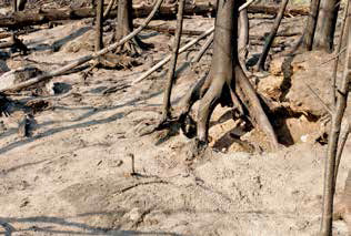
After a summer of little rain turned into drought conditions, a lightning strike several miles to the west started a small fire near Pagami Lake. After several days, the dry windy conditions allowed the fire to grow and on September 12th, it advanced an incredible sixteen miles in one day. Almost the entire Powwow Trail system was consumed as part of the 90,000 acres affected. What was once hidden by thick forest now was laid bare. All the old roads, trails, landings and portages were completely open again. Thousands of manmade remnants from the logging days re-appeared. The gray ash and denuded forest looked like a moonscape. The fire was so hot it burned the topsoil down several inches. Tree trunks minus most of their branches remained standing as sentinels over the remaining rock outcroppings, scorched swamps and miles of view afforded by standing on some of its highest vantage points.
The next half dozen years brought quick change to the environment. It’s amazing how soon nature returns to cover a scarred landscape. Grasses and wildflowers soon covered the forest floor. Jackpine cones, long ago shed, opened with the heat of the fires to start a whole new generation of the twisted species of pine. Unfortunately, with the thin soil, the standing trees that had burned had no support system to keep them upright. Wind and rain combined to topple them, a little at a time, to the ground below. What had been completely open a mere three or four years before became a jungle of new growth and dead blowdowns, impossible to move through.
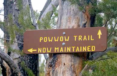
The Forest Service, swamped with caring for an area more known for its canoe traffic rather than hiking, decided not to open the Powwow Trail again. It was a sad time. A playground available to me for decades, was now gone.
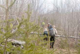
A group of hikers organized a 501c organization called the Boundary Waters Advisory Committee in 2019 to propose working with the Forest Service to once again clean and maintain the Powwow. The first efforts faced a monumental task. Flagging the old trail using GPS coordinates and making an inventory of what needed to be accomplished was a large undertaking in itself. Getting funding, growing its membership and developing a plan of action is always difficult. All work had to be done with hand tools and under restrictions as to group size and other BWCA restrictions.
And yet, they pulled it off. Thousands of blowdowns have been removed. Brush trimmed back and campsites restored on lakes almost forgotten with names like “Pose”, “Rock of Ages”, “Superstition” and “Campfire”.
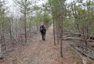
Six years later the trail is open and maintained and probably has more usage than it ever had.
I became involved because I felt I owed something to this area I had used for decades.
No one is happier than me.
I haven’t hiked the entire route, but I have done numerous day hikes at all times of the year. I hunt it regularly again. Some of the old landmarks are gone, but the same destinations remain. I have many memories, from its wildness that I first knew, to a gray ghostly landscape after the fire, to an exciting area of new growth. It won’t return to the state that I discovered it within my lifetime, but the adventure, the wilderness and the allure will remain forever. It is a paradise rising from the dark days of the Pagami Fire. Truly, a Phoenix!