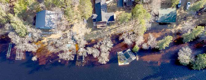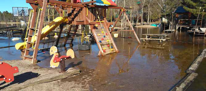
High water levels have resulted in flooding in the Ely area both near White Iron Lake and Fall Lake.
Flooding has occurred along roads and elsewhere, with a combination of melting snow, some heavy rains the week of April 24 and the regulation of water levels by way of the Birch Lake Dam causing significant problems for many area residents and business owners.
That’s particularly so at White Iron Bear Resort, where several cabins are not accessible for this weekend’s fishing opener as a result.
“We’ve got four cabins totally shut down,” said Kerry Davis, owner of White Iron Beach Resort. “We won’t be able to get into those for the opener and we had those booked. We’ve found relocations at a neighboring property. That’s revenue that will be lost. It’s just not good. Then I’ve got to pay three or four times the labor.”
Davis has owned White Iron Beach Resort for more than 30 years and called the current flooding “probably within the top one or two high-water events we’ve dealt with.”
Like many others in the region, Davis voiced some frustration with the management of water levels by Minnesota Power.
“You can’t do a lot about rain or snow but we really didn’t have much of a snow pack,” he said. “And we didn’t get 10 or 11 inches of rain at one time. I know that Minnesota Power says they have to stay within certain guidelines, but I feel there’s a really big disconnect from many years in the past about how the drawdown in the lake in the spring should be. Maybe there should be exceptions. Maybe they should go outside the guidelines for emergency situations.”
As of 10:15 a.m. Thursday, the National Weather Service had issued flood advisories for these streams and drainages: Isabella River, Moose River, Jeanette Creek, Horse River, Basswood River, Kawishiwi River, and Hustler River.
Addit iona l ra i n fa l l amounts up to 0.25 inches are expected over the area through early next week, and the NWS says to “Expect high, fast-moving water on area rivers and elevated lake levels. Water levels are near or above those seen during flood events in Spring 2022 and June 2024.”
Areas near the end of the Gunflint Trail and Ely will see slow decreases in elevated water levels through this weekend. For areas near and on Basswood Lake and Lac La Croix, expect rises to continue into this weekend, with peak flows expected during the week of May 11.
Those venturing into the Boundary Waters should prepare for high water and possible inundation of portages and campsites, as well as dangerous rapids and very cold water.
Some locations that will experience flooding include: Gunflint Lake, Snowbank Lake, Basswood Lake, Boundary Waters Canoe Area Wilderness, Fall Lake, White Iron Lake, Sea Gull Lake, Saganaga Lake, Ensign Lake, Disappointment Lake and Lac La Croix.