
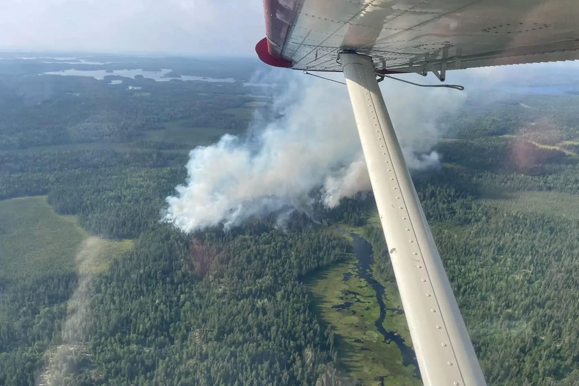
Continued wildfire growth has led the U.S. Forest Service to close all BWCA entry points on Tuesday, July 14. The closure was listed from July 14-17.
The U.S. Forest Service has been fighting a losing battle with over a dozen wildfires following a lightning storm a week ago. Those fires, along with extreme weather conditions, ignited the complete closure. "Beginning Tuesday, July 14, 2026, no visitors will be allowed to enter the BWCAW, including for day use," the agency stated.
The notice stated USFS crews will begin moving visitors out of the BWCAW on Tuesday with priority on areas most vulnerable to fire activity, full refunds will be processed automatically with permit holders receiving a cancellation notification email.
This is the first closure since 2021.
A post from Spirit of the Wilderness stated, "If you have friends or family in the BWCA know that not all of the BWCA is on fire. They are using extreme caution due to the weather conditions, current fires and the amount of personnel they have in place to make things safe."
Fires burning in the area include:
Dark Fire/Bear Trap: The Bear Trap Fire and Dark Fire have merged and are now collectively known as the Dark Fire/Bear Trap Fire. The fire now has a combined size of 700 acres, is burning toward Crooked Lake, and exhibiting very active fire activity.
Thumb Fire: Between Thumb and Contentment Lake in the BWCA. This fire has jumped to an estimated 600 acres in size. It was initially reported at 5:32 p.m. on July 7.
Sioux Fire: North of the Echo Trail and east of Jeanette Campground and estimated at 288 acres. The fire was burning toward the BWCA and at 8 p.m. Sunday night the Forest Service was removing vehicles from the Little Indian Sioux entry point parking lot due to the wildfire's direction of spread. This fire includes evacuation notices:
St. Louis County Sheriff Wildfire Evacuation Map
Wolfpack Fire: Burning four miles north of the Echo Trail and the Lake Jeanette Campground. Listed as 80 acres Sunday night.
Echo 2 Fire: A 14 acre fire north of Echo Lake also with evacuation orders in place.
There are a half dozen additional fires west of the Crane Lake Road with the Marion Creek and Beaver Trail fires also having evacuation zones in place.
On the evening of July 6, , a storm system moved through the area with thunder and lightning and little precipitation. The following day, several small wildfires were reported. Local and off‑forest firefighting resources are conducting suppression on these fires. With warm and dry summer conditions, additional wildfires are being detected daily.
To help ensure public safety and protect natural resources, the Minnesota Department of Natural Resources activated burning restrictions at 8 a.m. Sunday, July 12, for Cook, Lake, and northern St. Louis counties in northeast Minnesota. These restrictions apply to non-federal and non-Tribal lands in the affected area.
In the areas affected by the restrictions:
- No campfires are allowed for dispersed, remote, backpacking, or backcountry camping on all lands, whether there is a designated fire ring or not. On state lands, this means campfires are not allowed in state forests, state day-use or recreational areas, or backpacking sites in state parks.
- Campfires are allowed only in an established fire ring associated with a state park, home, cabin, permanent campground, or resort.
- No burning of brush or yard waste is allowed. Burning permits will not be issued or activated.
- No fireworks may be ignited on any public or private land outside city limits.
These restrictions are consistent with burning restrictions that are being implemented by the Bois Forte Band of Chippewa and Voyageurs National Park. In addition, the U.S. Forest Service has issued restrictions for all campfires in the Superior National Forest in these counties and throughout the Boundary Waters Canoe Area Wilderness.
"The risk of fire is increased with these unusually dry conditions in the area in combination with the predicted hot, dry, and windy conditions starting Sunday, “said Karen Harrison, wildfire prevention specialist. "One unintentional spark could result in thousands of charred acres and property damage."
While the DNR and wildfire agencies are ready to respond, the responsibility for preventing wildfires largely falls to people.
“We don’t issue burning restrictions lightly. And Minnesotans have a history of making a difference in preventing wildfires when they keep safety top of mind,” Harrison said.
With little precipitation and above-average temperatures in the extended forecast, fire danger is likely to remain high until the area receives significant precipitation. The burning restrictions will remain in effect until terminated by the DNR. This will happen after weather and environmental conditions indicate a significant reduction in fire danger.
The health and safety of people and firefighters is paramount. If you spot a wildfire, call 911 from a safe location.
Governor Tim Walz Sunday issued Executive Order 26-08 declaring a peacetime emergency and authorizing additional state assistance to support ongoing wildfire response efforts in northern Minnesota.
“Wildfires have broken out in northeastern Minnesota and are putting local communities at risk,” said Governor Walz. “This emergency declaration allows for the mobilization of additional resources necessary to protect lives, prevent damage, and help the Minnesota DNR and our local communities respond. Minnesotans extend our deepest gratitude to the firefighters, members of the Minnesota National Guard, and all our first responders working around the clock to keep their neighbors safe.”
The declaration comes as unusually dry conditions and lightning strikes have created dangerous wildfire risk across much of northeastern Minnesota. Since July 10, multiple fires have ignited in portions of Koochiching, Lake, and St. Louis counties, potentially threatening lives, property, and critical infrastructure. As current weather conditions pose a continued risk for rapid fire growth and spread, the National Weather Service has issued a Red Flag Warning for extreme fire risk.
Beginning on July 11, 2026, the United States Forest Service closed 225,000 acres of the Boundary Waters Canoe Area Wilderness because of multiple wildfires and continued dry conditions. The US Forest Service reports that 17 wildfires have started in and around the BWCAW in the last week, which have resulted in evacuations and the closure of multiple trails and entry points. These fires are impacting the northwest part of the area, between Ely and Crane Lake, north of the Echo Trail and south of Lac La Croix along the Canadian border. In addition, the Minnesota DNR is leading response on five other fires in the same area.
The Minnesota Department of Public Safety’s Division of Homeland Security and Emergency Management is coordinating closely with federal, state, and local partners to support fire suppression, evacuation efforts, and emergency response operations. Responding agencies include the Minnesota Department of Natural Resources, Minnesota Department of Transportation, the Minnesota Interagency Fire Center, US Forest Service, and local emergency responders.
At the request of the Department of Natural Resources, the Executive Order authorizes the Minnesota National Guard to provide personnel, equipment, and resources to assist with wildfire suppression and emergency response efforts.