
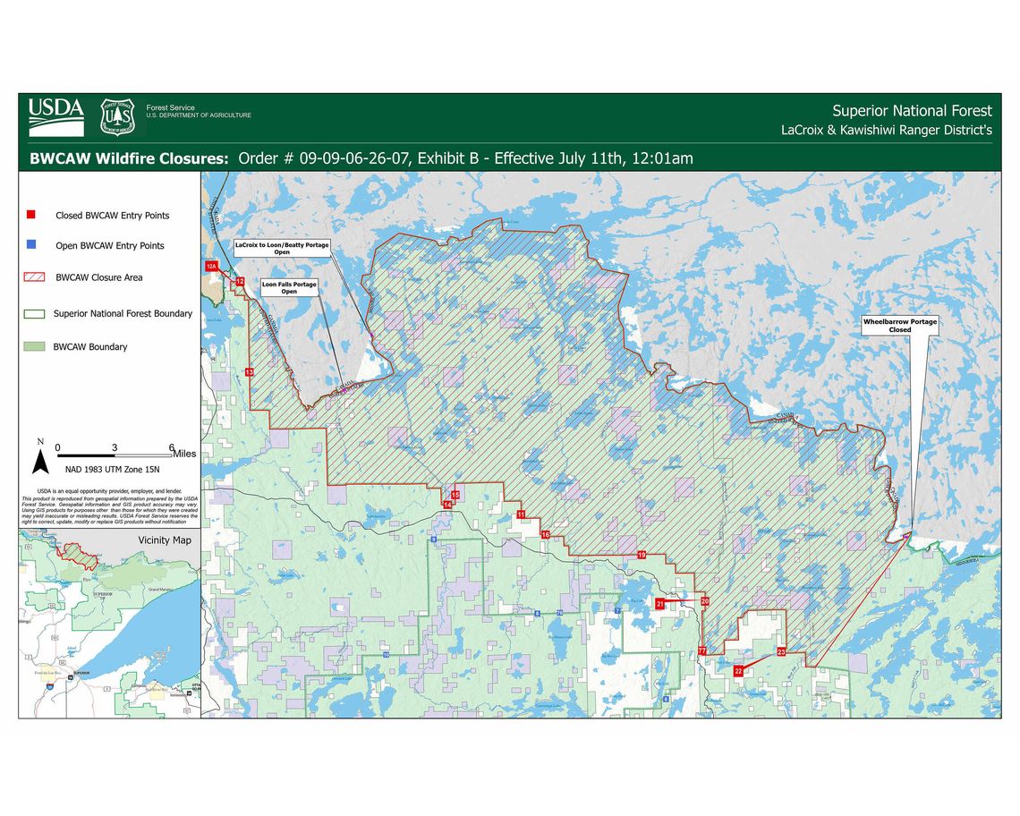
The U.S. Forest Service issued temporary closure orders for 13 Boundary Waters Canoe Area Wilderness (BWCAW) access points, effective Saturday, July 11.
Angleworm Lake (OP) #20, Angleworm Trail (OH) #21, Blandin Trail (OH) #11, Herriman Trail (OH) #13, Little Indian Sioux River North (OP) #14, Little Vermilion Lake (OP, OM) #12, Lac La Croix Only (OP, OM) #12A, Moose/Portage River North (OP) #16, Mudro Lake – Restricted (OP) #22, Mudro Lake (OP) #23, South Hegman Lake (OP) #77, Stuart River (OP) #19 and the Sioux Hustler Trail (OH) #15 access points will be closed until further notice.
Superior National Forest authorities cited public safety concerns brought on by the Thumb, Wolfpack and Bear Trap wildfires for the restrictions. All three wildfires are within the LaCroix Ranger District.
Ongoing wildfires and dry conditions additionally led the Superior National Forest to issue an Emergency Forest Order on Friday to restrict campfires within the BWCAW, effective July 11 until further notice.
Authorities wrote in an emailed statement that the new order will restrict “the ignition, building, maintaining, attending, or using a fire or campfire, including charcoal grills and barbeques, coal, and woodburning stoves.”
Campers may use gas or propane cooking stoves, but no stoves or grills fueled by charcoal or food.
Limitations aim to prevent further wildfire incidents.
The Forest Service recommends added precautions when using smoking devices, dragging chains, recreational vehicles and other potential sources of sparks.
Outside of the Boundary Waters where bans have not been implemented, authorities urge campfire users to ensure their fires are completely cold to the touch after use.
Wildfire updates are available via InciWeb or Watch Duty. Recent updates, in decreasing order of wildfire acreage, are listed below.
Thumb Fire
The Thumb Fire had expanded to 20 acres as of Thursday at 4:53 p.m. The incident is located in a remote area of the Boundary Waters near Thumb Lake, south of Lac La Croix. The locale poses a challenge to access, but area firefighting resources responded to the fire Thursday by dropping water on the location via aircraft.
Sioux Fire
The Sioux Fire’s acreage jumped to six as of Friday at 9:24 a.m., as reported by WildCAD, an online dispatch system. It is located just north of the Echo Trail and west of Little Indian Sioux River.
Nine Fire
Nine Fire was active as of Friday at 6:42 a.m., having burned four acres since it was first reported by WildCAD on Thursday at 3:50 p.m. It is located just north of the Echo Trail, south of Echo Lake and immediately west of Forest Road 1007 in St. Louis County.
Section Three Pond Fire
The Section Three Pond incident had reached full containment at 2.3 acres by Friday at 8:35 a.m. Firefighting personnel dropped water on the fire from the air on Wednesday in order to lower the fire’s intensity, supporting the safety of the four firefighters who accessed the area via ground on Thursday. These four personnel applied a direct extinguishment strategy to limit the fire’s spread.
The incident is located south of Lac La Croix in a remote area near the Canadian border.
Bear Trap Fire
The Bear Trap Fire, off the Bear Trap River and north of Sunday Lake in the BWCAW, had burned two acres as of Thursday at 3:52 p.m. Local firefighting personnel have responded to the incident via aerial support. On Wednesday, single-engine air tankers repeatedly dropped water on the fire, eliminating smoke from the fire. Suppression will continue as needed.
Fools Gold Fire
The Fools Gold Fire had burned 1.5 acres West of Norway Road and south of Lake Jeanette in the Superior National Forest by Thursday at 3:44 p.m. On Thursday, five firefighters conducted direct on-the-ground suppression following Wednesday’s aerial efforts. A water tanker, which transports water, joined the crew on the job. Further resources were ordered to the fire.
Camp Fire
The Camp Fire is located eight miles north of the Cloquet Line, north of Ely. Its size has been updated to 1.06 acres. There were eight personnel on the fire as of Thursday, following Wednesday’s aerial water drops. Responders plan to continue direct extinguishment strategies.
Newton Fire
The Newton Fire on Newton Lake north of Fall Lake reached 100% containment by 3:47 p.m. on Wednesday at just a quarter acre in size.