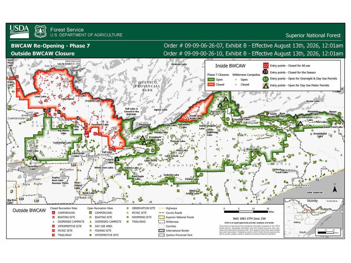
Starting Aug. 13, the U.S. Forest Service will have opened over 1,500 of the 2,000 plus campsites within the one-million-acre Boundary Waters Canoe Area Wilderness (BWCAW). The Forest Service will reopen entry points around Big Moose and Big Lake. The following paddle areas will change access status effective August 13:
- Kawishiwi District - Open to use
- 7 From Big Lake
- LaCroix District - Open to use
- 8 Moose River South
- 9 Little Indian Sioux River South
- 10 Norway Trail
- 76 Big Moose Trail
- The Forest will extend permit cancellations for entry point C – Fall Lake Only (Motor Use) and the Jeanette Campground to Aug. 17.
For maps and more information on the Phase 7 partial reopening and ongoing fire restrictions please visit: https://fs.usda.gov/r09/superior/alerts.
The Forest Service will reopen additional recreation areas for the public beginning Aug. 13.
Areas reopening include Big Lake Boat access and campsites, and other smaller recreation lakes and backcountry sites along the Echo Trail. This marks the first time these locations will be accessible since they were closed on July 15 due to the July Lightning Wildfire Incident.
Wildfire activity in proximity to these campgrounds is moderating, allowing for this reopening. However, the Forest Service reminds the public that if wildfire activity increases, reopening plans may be adjusted. Protecting both the public and firefighting personnel remains the highest priority.
Some developed recreation sites on the west side of the Forest remain closed.
Class III fire restrictions are still in effect on the Superior National Forest, in coordination with partners. Campfires are restricted to designated fire rings in developed and rustic campgrounds and prohibited in the BWCAW. Despite recent and scattered precipitation, fire danger across the forest varies from moderate to high.
While some portions of the BWCAW are reopened, other areas remain impacted by suppression efforts and continued wildfire activity from the Camp, Bear Trap, Sioux and Thumb Fires.
The Forest Service reminds visitors to be diligent in planning trips into newly reopened and all parts of the BWCAW. Plan to be self-sufficient; ensure a travel plan is in place and shared with family or friends; check weather forecasts and fire conditions before your trip; travel with multiple means of communication; and understand that you are entering a remote Wilderness area with risks due to weather, access, and potential wildfire activity.
The Forest Service continues to work with partners, along with evaluating current and forecasted fire activity, available firefighting resources and progress of fire suppression activities in reopening recreation areas impacted by wildfires.
Frequently Asked Questions
Q. Why was the BWCAW initially closed?
A. Beginning July 7, the Superior National Forest experienced more than 25 wildfires fueled by extremely dry conditions and hot, windy weather far outside typical summer patterns. Several fires remain active and uncontained, and firefighters continue suppression efforts throughout the Forest, including inside the BWCAW. To protect both the public and firefighting personnel, the Forest Service temporarily closed the Wilderness on July 14.
Q. Why isn’t the entire BWCAW reopening?
A. There are portions of the BWCAW that continue to burn, and other areas were heavily impacted by wildfire during weather-driven fire spread. Crews continue to assess damages to portages and campsites, clear hazardous standing and fallen trees, and replace damaged infrastructure such as latrines, portage trail features and more.
Wilderness assessment, rehabilitation, and infrastructure replacement will take time. Some of the work, for example hauling in and replacing latrines, is best done during winter months by using dog sled teams over snow. The Forest Service works to ensure public safety remains the first priority while balancing the public’s interest in utilizing these access points. As conditions improve and accessibility is restored, portions of the BWCAW will continue to be incrementally reopened.
Q. This reopening is Phase 7. What were the earlier phases?
A. The Forest Service has used a phased approach to reopen the BWCAW as soon as feasible given the conditions of each entry point. These phases have been:
- Phase 1, which went into effect on July 27, allowed day use in parts of Cook County.
- Phase 2, which went into effect on July 30, reopened additional day and overnight use permits in central and eastern parts of the BWCAW.
- Phase 3, which went into effect on July 31, added additional day and overnight use on several entry points across Cook, Lake, and St. Louis Counties.
- Phase 4, which went into effect on Aug. 4, continues the phased reopening by opening more sites on the eastern portions of the Forest to “day and overnight” use.
- Phase 5, which went into effect on Aug. 5, reopens additional entry points on the western portions of the Forest to overnight use.
- Phase 6, goes into effect on Aug. 11, reopens entry points closer to wildfire areas across the forest.
- This phase, Phase 7, goes into effect Aug. 13, reopens five entry points.
Q. If I have a permit for an entry point listed in Exhibit A-List that is after the current effective date, can I enter the BWCAW?
A. Yes—if your entry point is listed in Exhibit A-List and is on or after the current effective date, that entry point has reopened based on current conditions and accessibility. However, because wildfires can change rapidly, visitors should continue to check current conditions and alerts on the Forest’s website and understand that Phase 5 could be delayed if wildfire conditions increase and entry points become impacted by the fires. Public and firefighter safety is the Forest Service’s highest priority.
Q. How do I find daily updates or more about the current fires?
A. Visit InciWeb, the official National Fire Incident System: https://inciweb.wildfire.gov/incident-information/mnsuf-july-2026-superior-nf-wildfires